


The peninsula of Kermorvan
The headland of Kermorvan, at Le Conquet, was in Neolithic times a hill with steep slopes overhanging undoubtedly meadows and swamps. Its configuration with two narrowed parts, now isthms, made it a particularly easy site to occupy and defend. With the rise in sea level, the value of this strategic position has further increased and it should come as no surprise that many prehistoric remains, megaliths and tombs of the Bronze Age, are adjacent with remains of military fortifications from all eras, up to the bunkers of the Second World War, having considerably upset the landscape.
Access :
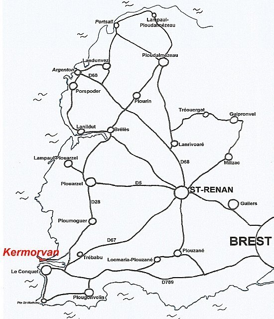
Coming from Brest or Le Conquet, take the road between the inner port of Le Conquet and the pond of Kerjan, direction St-Renan, Plouarzel. Turn left at the first crossroads towards Ploumoguer-Plouarzel. At the next crossroads, turn left towards the Kermorvan peninsula and the Blancs Sablons beach.
Coming from St-Renan on the D67, 1 km before Le Conquet, turn right at the crossroads just after the restaurant "Le Charldann". At the next crossroads, turn left towards Blancs Sablons beach.
Coming from Ploumoguer on the D28, turn right towards the Blancs Sablons beach at a crossroads located in a wide bend. Parking in the isthmus at the end of the road.
Today, for summer visitors and weekend residents of Brest, the headland of Kermorvan is a must for swimmers, hikers, windsurfers and paragliders. A long beach and a still wild peninsula attract many tourists.
This small peninsula that separates the port of Le Conquet from Blancs Sablons beach has seen the peoples of the Neolithic erect dozens of megaliths including several dolmens. One of them, some of whose pillars are decorated with cups and engravings, has even been the object of casts that are kept at the Museum of Prehistory in Penmarc'h.
Le musée de Penmarc'h
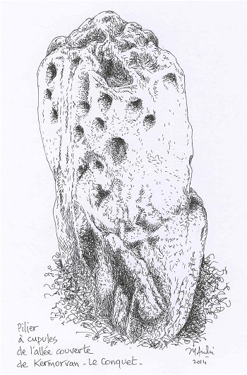
Drawing by Jean-Yves André©
Unfortunately, not much remains today, as agriculture and the military defence of the coast have always prevailed over the conservation of a heritage considered obsolete. However, it should be noted that in the middle of the war, in 1916, Captain G. du Plessix, when digging fortifications, discovered a large slab engraved with a dagger coming out of its sheath in the moors near the present campsite. He reported this discovery to Commander Alfred Devoir, who was an archaeologist. Albert Devoir bought the stone from the owner of the land and gave it to the Museum of Prehistory in Penmarc'h where the engraved slab is still on display.
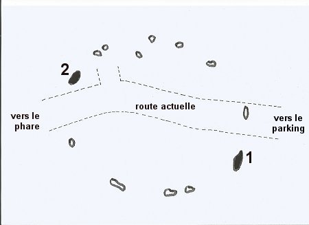
1
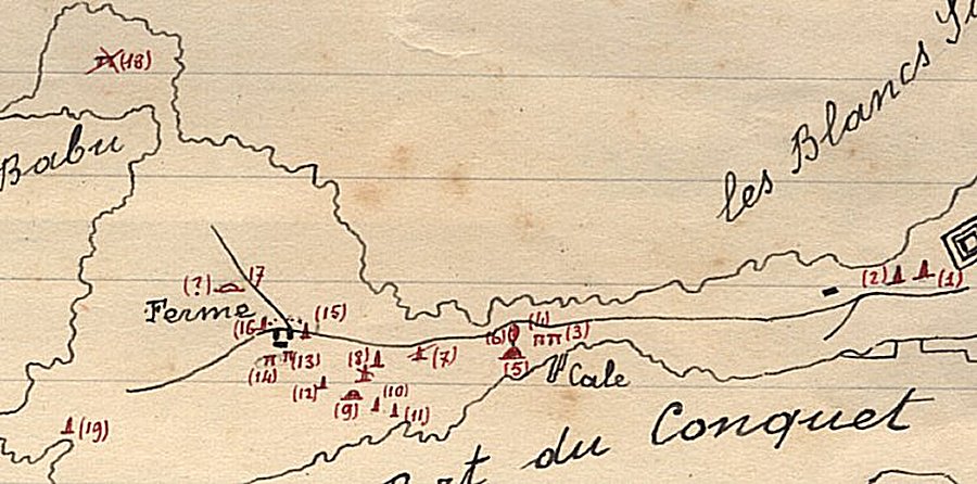
Map prepared by archaeologist Alfred Devoir in 1909
One will notice the important number of megaliths still counted.
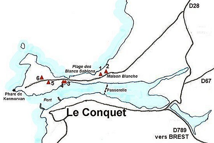
Only numbers 1, 2, 10, 11, 15 and 16, still visible today, are described below.
Today, the walker can only discover six megaliths : two menhirs in the moor at the place called Maison Blanche, east of the car park, then two others of small size along the coastal path along the port, and finally the two stones rescued from a cromlech located on either side of the small road reserved for pedestrians after the barrier.
WHITE HOUSE MENHIRS
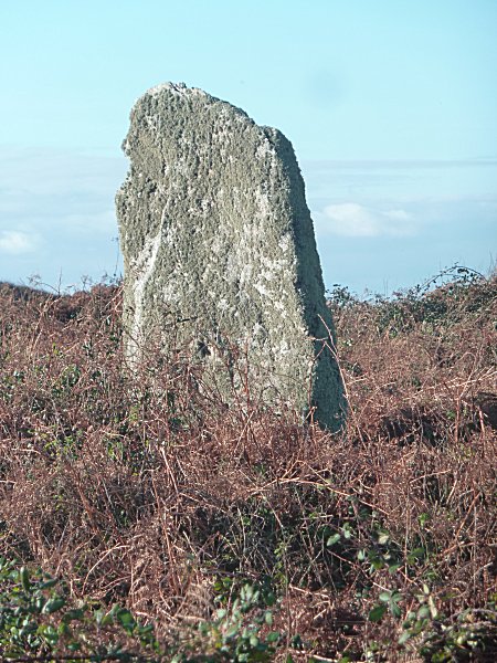
-1- The WEST menhir
Access:
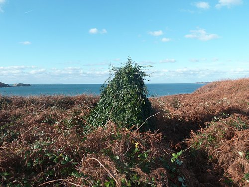
From the isthmus car park, walk back on the asphalt road and turn left, opposite a pedestrian crossing, onto a path heading towards the sea, whose entrance is framed by two large rocks. A few metres to the right you can see a small menhir in the ferns.
This stone, very discreet, is easily covered by vegetation. Its height is only 1.10 m while its width reaches 1.25 m for a thickness of 0.65 m. It has not been cut and consists of granodiorite from Fox Point.
The West Menhir of the White House, above seen by the slice
and below showing its south face.
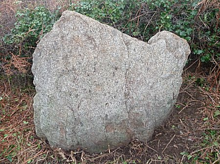
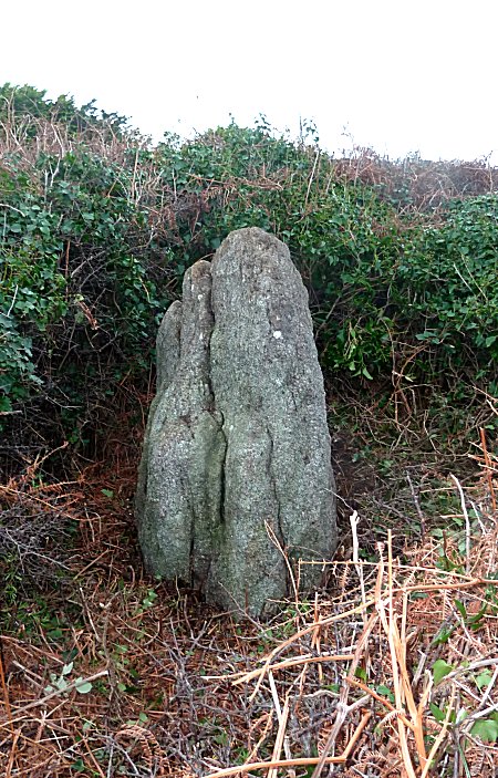
-2- The EAST menhir

Access :
Continue the path that leads to the GR34 along the Anse des Blancs Sablons. Turn right towards the beach. At about fifty meters, a breach on the right in the slope makes it possible to see in the south the top rather distant from the second menhir among the ferns. From the GR34, the access is difficult in winter when the faded vegetation is however laid down by wind and rain. It is not at all recommended to try to achieve this in another season: brambles, very high ferns and possible presence of vipers.
GPS : 48°21'53 N 4°46'07 W
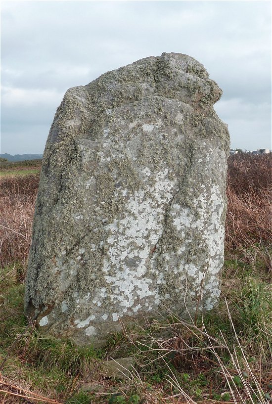
It is a 1.83 m high stone with a width of 1.70 m and a thickness of 1.10 m at the base. Not a giant, then, but a big menhir who possesses the rare talent, for such a monument, to know how to disguise itself in a few years to go completely unnoticed in the landscape. You would guess a megalith, you, under this lost ivy hairstyle in the middle of an inextricable entanglement of ferns and brambles?
The East menhir of the White House, south face, in autumn 2014
The East menhir of the White House, North Face
After the hairdresser, the stone is a little more presentable. Emerging from a thick bed of ferns, it was part of a group of three menhirs a few tens of metres apart, described from the time when no construction still existed on the tevenn, the dune. Made of granodiorite from the Fox Point, in Le Conquet, it was not cut at all.
A third menhir?
In a 1903 publication, P. du Chatellier reported a third menhir 0.90m high, about sixty metres west of the first, and practically aligned with the other two. This stone, not found since, is not reported by Alfred Devoir in 1909. So it disappeared between those two dates.
THE TWO SMALL MENHIRS OF THE PORT
Access :
From the isthmus car park, walk across the barrier and up the unpaved path that runs alongside the port. After this hill, a series of large rock outcrops dot the path. As soon as they stop, a deep depression can be seen on the left of the path, and on the right a small passage through the brambles and ferns towards an isolated tree. The first little menhir is there, a few meters from the path, hidden in the ferns.
-1- The EAST Menhir:
GPS : 48°21'47.5 N 4°46'43 W
This first menhir does not exceed 1 m above ground for an equal width and a thickness of 0.30 m. As the terrain is sloping and the layer of ferns thick, it is likely that its buried part is more important.
Drawing by Jean-Yves André©
-2- The WEST menhir
GPS : 48°21'47.4 N 4°46'43.2 W
The second menhir, only 6 m away, is located slightly higher and to the west on the slope. Its shape is triangular, its height reaches 1.10 m and its width at the base 1.45 m for a thickness of 0.30 m.
Drawing by Jean-Yves André©
Menhirs often come in pairs.
These two stoic sentinels monitor the port of Le Conquet
for thousands of years.
CROMLECH RESCAPES
Classified Historic Monuments October 22, 1913

Access :
It is necessary to go up the small asphalt road, west of the barrier, leading to the lighthouse of Kermorvan. The two megaliths are only 200 m away.
GPS : 48°21'50 N 4°46'52.9 W
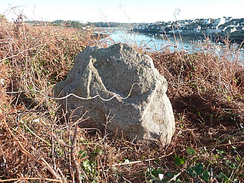
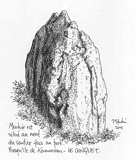
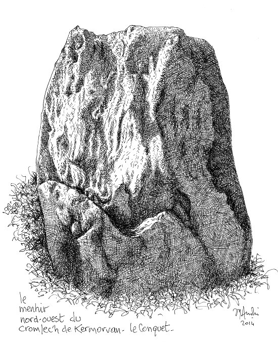
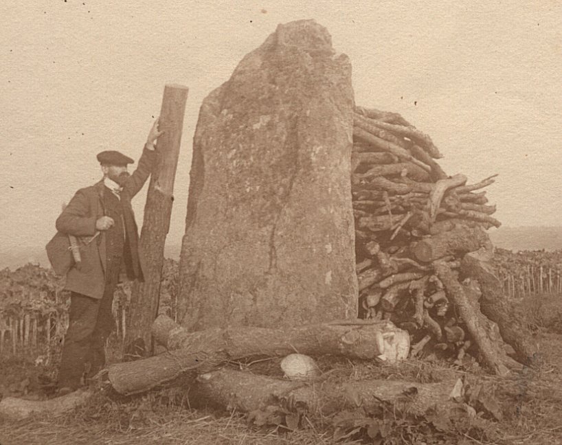
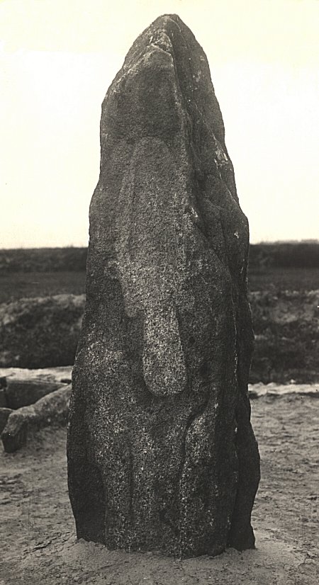
The menhir n°1 of the cromlech
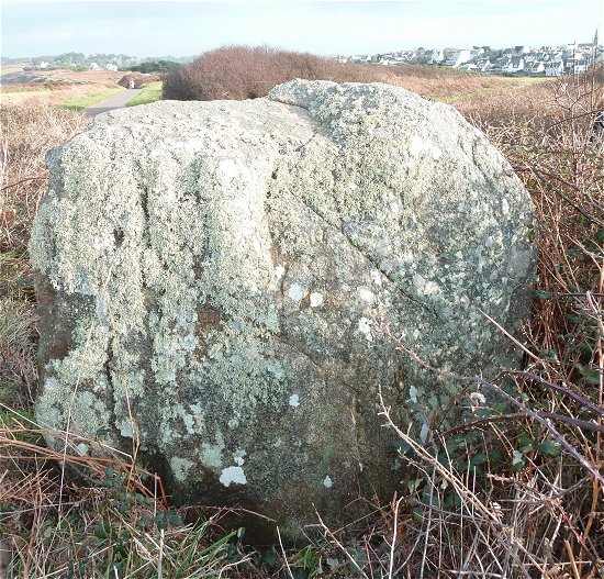
The first, photo and drawing below, in gneiss, is a little back on the left of the road. It can be reached quite easily from the first field entry on the left after the stone. Emerging from brush, it measures 2.5 m in height and its base is 1.70 x 0.57 m. It is the largest stone - thus the least easy to remove - of a circle of menhirs which included at least thirteen.
The menhir n°1 of the cromlech

The menhir n°1 of the cromlech
Drawing by Jean-Yves André©
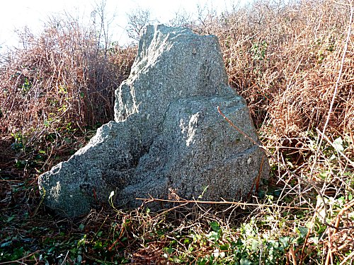
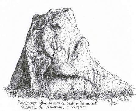
The menhir n°2 of the cromlech
GPS : 48°21'50.4 N 4°46'55.6 W
This second menhir, smaller but stocky, ( photo and drawing below) is a few steps further at the edge of a cultivated plot to the northwest of the road. Consisting of gneissic granodiorite, it measures 1.78 m in height and width, with a thickness of 0.82 m at the base.
The menhir n°2 of the cromlech
The second menhir of the cromlech.
Drawing by Jean-Yves André©
For several years, at the beginning of the XXth century, this menhir was incorporated into a small construction dependent on a neighbouring disappeared farm, a kind of barn or shelter for farm animals, in dry stones, of which the megalith constituted a part of the gable.
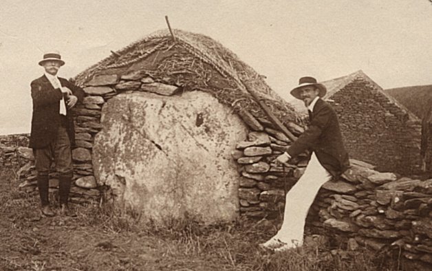
The second menhir of the cromlech in 1909. Photo Alfred Devoir
In fact these two menhirs of Kermorvan were part of a cromlech in the shape of an ellipse which included, according to the authors, 12 or 13 megaliths.
A very free reconstruction of this cromlech was made in 2005 for the shooting of the TV film "Dolmen" on the Kermorvan peninsula. This decor was later dismantled.

Captain Christophe-Paulin de la Poix, Chevalier de Fréminville, wrote in 1832 in
" Antiquités du Finistère "
:
..." I arrived at the sanctuary or Cromlec'h composed of twelve stones planted standing in the ground so as to form an elliptical enclosure one hundred eighty-five feet long by one hundred twenty feet in its widest width. The highest stons of this Cromlec'h is that of the eastern end : it has eight feet of elevation. Facing the west side and diametrically opposite is a stone six feet high; all the others are smaller. »
The foot corresponding in France to 0.324 m, the dimensions of this ellipse were about 60 x 39 m.
We often hear, at Le Conquet, that the cromlech was destroyed by the Germans during the Second World War to let through cannons intended for the defence of Kermorvan Point. There is obviously confusion since the author of the above quotation adds :
...« Such are the Druidic monuments of the peninsula of Kermorvan, or rather, such they were, for I was very sorry to know that they had recently been completely destroyed, and their stones deplanted, broken and cut to be used in modern constructions."
His book having been published in 1834, the destruction of the cromlech is thus located between 1832 and 1834 and it is french troops, at the time, which cleared a ground of a military area. The confusion comes from the fact that German troops destroyed other megaliths on the peninsula.
MISSING MEGALITHS
The menhir n°12 on Alfred Devoir's map established in 1909 has completely disappeared.
It must have been near the farm, south of the cromlech.
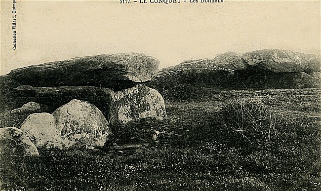
This menhir was separated from the cromlech by two large dolmens ( n°13 and n°14 on the map Devoir) classified since October 22, 1913.
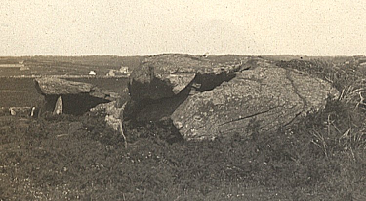
One can imagine how much these monuments, cromlech, dolmens and menhirs could have constituted a high prehistoric place. All this set does not exist any more.
The postcards of Le Conquet still show us other structures that have disappeared.
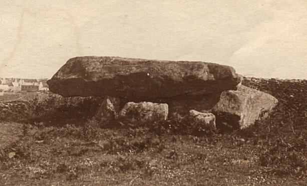
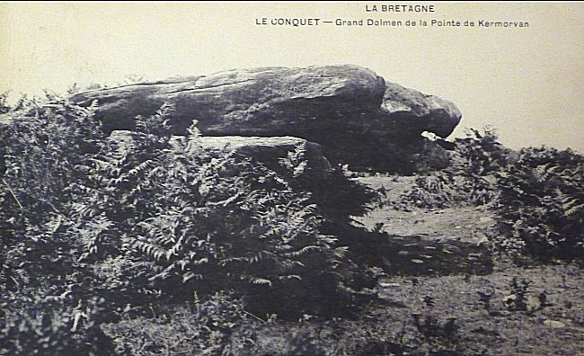
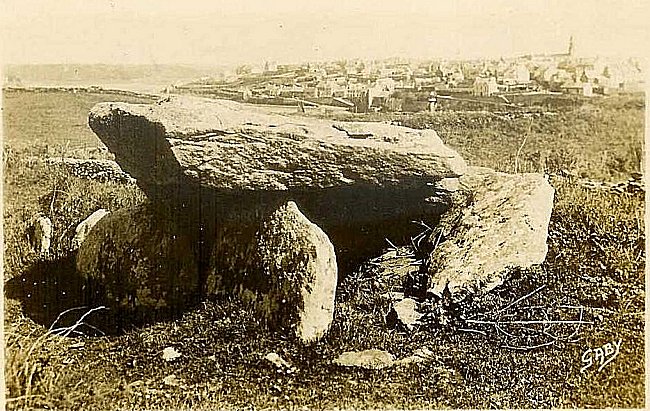
Preserved intact by all the generations during about fifty centuries - it is not nothing - these megaliths of Kermorvan did not resist the human unconsciousness since 150 years...
***
-1-G.du Plessix :
"Discovery of a carved stone in the Kermorvan's moors"
Bulletin de la Société Archéologique de Nantes, 1918, tome 58, p.3 à 11.
"Menhir" of the Tévenn of Kermorvan, classified historical monument,
currently on display inside the Museum of Prehistory in Penmarc'h.
The relief engraving would represent a dagger coming out of its sheath.
The stone, discovered lying down, could be a middle Neolithic menhir,
later re-used as a grave slab.
***
QR code of this page
Download this flashcode